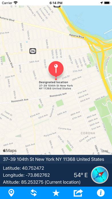
Geo Elevation: Path Analyzer is a navigation app developed by ObjectGraph LLC. The last update, v1.60, released on November 08, 2025, and it’s rated 3.10 out of 5 based on the latest 10 reviews. Geo Elevation: Path Analyzer costs $1.99 and requires iOS 17.6+ and Android 16.6 or newer to download.
Description
Geo Elevation - Elevation Profile Visualizer
Create beautiful elevation profiles by drawing paths on a map.
How to Use Geo Elevation: Path Analyzer on Your PC or Mac
Want to enjoy Geo Elevation: Path Analyzer on your desktop? Download the latest APK (1.60, 4 MB) or choose your preferred version, and follow our Bluestacks emulator guide for easy installation on Windows or macOS. For any assistance with downloading or installing APK files, feel free to visit our forums!
User Reviews and Ratings
★★★★☆Really Like It
There are two things that would be useful to add. One is to use the GPS to determine your location and give the elevation. The other is to place a mark on the spot if you use an address.
★★★★★Bill
I use this App for amateur radio applications to determine the distance and elevation between stations I contact on the radio. It is great for figuring out if I can work a station on VHF or UHF direct or accessing repeaters.
★★★☆☆Could be good but has a bug
Scale on left side of graph is overlapped by the word 'Elevation' and doesn't allow you to read the measurements. Fix this and I will find it useful.
★★★★☆Geo Elevation
Great app at least in my opinion. Hard sometimes to get precision on map due to touch on iPad but that goes without saying. Depends on what you are using app for as to what is best for everyone but the main thing is you can do elevation and depth in ocean that's pretty darn good. I have done my home work and oceanography is my field of study main study being ocean bathymetry. Was well worth what I paid.
★★★★☆Hello
Please update this app , because dont open with ios 11